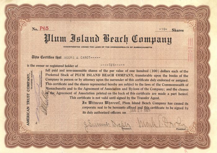
Plum Island Beach Co. - Stock Certificate
Inv# GS6038 Stock
Stock printed by American Bank Note Company. Newburyport, Massachusetts.
Plum Island is a barrier island located off the northeast coast of Massachusetts, north of Cape Ann, in the United States. It is approximately 11 miles (18 km) in length. The island is named for the wild beach plum shrubs that grow on its dunes, but is also famous for the purple sands at high tide, which get their color from small crystals of pink pyrope garnet. It is located in parts of four municipalities in Essex County. From north to south they are the city of Newburyport, and the towns of Newbury, Rowley, and Ipswich.
Plum Island appears as an unnamed island as early as Captain John Smith's map of New England. Various scholars have speculated on the nature of the earlier accounts of European explorers in the New World, with particular focus on the latter's surveys of the coastlines of Massachusetts, but Smith's account identifies Plum Island. He describes a harbor at "Angoam" (elsewhere "Aggawom", the Anglicised Native American name for the native village that preceded Ipswich, Massachusetts, and was destroyed by smallpox) as having "many sands" at its entrance. Before it was an island:
On the east is an Ile two or three leagues in length; the one halfe, plain morish grass fit for pasture, with many faire high groves of mulberry trees gardens; and there is also Oaks, Pines and other woods to make this place an excellent habitation, being a good and safe harbor.
"Morish" is now "marsh", and the high gardens of "mulberry" trees may be beach plum, which prefers the crowns of the dunes, although today can be seen on only a few. The map shows an imaginary English town (the insertion of Charles I of England) of the then-future "South Hampton", about where Newbury is. The Hampton suggestions were later put to use, but further north.
A grant in 1621 by the Plymouth Council for New England, acting under a charter from James I of England (not then reigning) to colonize New England, deeded the land between the "Naumkeag" and Merrimack rivers to Captain John Mason. The island was to be named the Isle of Mason. Mason, then governor of Newfoundland, never acted on the grant. It was later included in a similar grant to the Massachusetts Bay Colony; nevertheless, in 1681 the heirs of John Mason petitioned the General Court of Massachusetts for possession of the grant, now colonized by several communities. After a trial before justices appointed for the purpose, the General Court decided it could not honor the claim, as no one then knew the location of the Naumkeag River, and in any case Mason's grant had been included in another. It did assess a nominal quit-rent fee of a few shillings on land-holders undeniably within the tract; that is, as far south as Ipswich.
Ipswich, Massachusetts, was incorporated as Ipswich in 1634 by settlers of the previous year from the Massachusetts Bay Colony. In 1635 another group from England passed through Ipswich to settle and incorporate Newbury, Massachusetts. In 1639 a third group from England was granted the remaining land between Newbury and Ipswich and incorporated Rowley, Massachusetts. There is no official record of the use of Plum Island until then, although Smith's glowing report had included the marsh grass, an enticing feature for herdsmen. A document of January 2, 1639, survives, however, by which Robert Wallis and Thomas Manning of Ipswich agree to maintain a common herd of 48 hogs on Plum Island starting on April 10 and running to the end of the harvest. One of them was always to be present. Reaction of the other communities was immediate. Newbury filed a petition with the General Court of Massachusetts for ownership of the entire island. The petition was denied on March 13 with the proviso that Ipswich, Rowley and Newbury were allowed use of the island, which became a pasture for hogs, cattle and horses.
In March 1649 Newbury again pressed for title to the island. It argued that "for three of four miles together there is no channel betwixt us and it." At low tide they drove wagons across. These arguments did not prevail; on October 17, 1649, the court finalized its temporary decision, apportioning 2/5 of the island to Newbury, 2/5 to Ipswich and 1/5 to Rowley. There is no hint in the court documents that they ever used a name other than Plum Island. The name is apparently of local origin; the journal of Margaret Smith (1678-9) relates:
Leaving on our right hand Plum Island (so-called on account of the rare Plums which do grow upon it), we struck into the open Sea....
In 1776, during the American Revolutionary War, Fort Philip was built on the northern point of the island to defend the Merrimack River. The fort was rebuilt by the federal government in 1808 and served in the War of 1812. The fort's site eroded away in the 1830s, destroying it.
An historian of the region, Joshua Coffin, said of it in 1845:
Plum Island, a wild and fantastical sand beach, is thrown up by the joint power of winds and waves into the thousand wanton figures of a snow drift.
A stock certificate is issued by businesses, usually companies. A stock is part of the permanent finance of a business. Normally, they are never repaid, and the investor can recover his/her money only by selling to another investor. Most stocks, or also called shares, earn dividends, at the business's discretion, depending on how well it has traded. A stockholder or shareholder is a part-owner of the business that issued the stock certificates.


Ebay ID: labarre_galleries